Showing 228 items matching entrance card
-
 Unions Ballarat
Printed materials retained by the branch. Amalgamated Society of Carpenters and Joiners, Ballarat Branch, 1901-1916
... Entrance card.... Entrance card to the Amalgamated Society of Carpenters and Joiners... November 1911. 11. Entrance card to the Amalgamated Society ...The membership began affiliation with its British parent union from the 1850s. It officially registered as Australian District of Amalgamated Society of Carpenters and Joiners in 1911. In 1945 it changed its name to Building Workers' Industrial Union (BWIU). The BWIU was deregistered in 1948 and re-formed in 1952. After subsequent amalgamations, the Australian Workers Union (AWU) now has coverage of these members.Printed materials retained by the Branch. Indicative of contemporaneous events and interests of the union.Printed material in three boxes. 1. Monthly reports of the Amalgamated Society of Carpenters and Joiners of Australasia 1901 September, November, December 1902 February, July 1903 April, May, November 1904 February-July 1908 May, December 1910 April, July, September-December 2. Monthly reports of the Amalgamated Society of Carpenters and Joiners of Great Britain 1902 Nos. 474-480, June-December 1903 No. 481, January; No. 483, March; No. 485, May; Nos. 487-488, July-August; No. 491, November. 1904 Nos. 494-498, February-June. 1905 No. 506, February; No. 511, July; No. 513, September. 1906 No. 519, March; Nos. 522-524, June-August. 1907 No. 533, May. 1908 Nos. 546-547, June, Jul; Nos. 549-552, September-December. 1909 No. 552, Jan; Nos. 556-557, April, May; No. 564, December. 1910 No. 565, January; Nos. 567-569, March-May. New Series 1911 Nos. 6-8, June-August; No. 10, October. 1912 Nos. 13-15, Jan-March; Nos. 18-20, June-August; No. 22, October; No. 24, December. 1913 No. 26, February. 1914 No. 42, June. 3. Annual reports of the Amalgamated Society of Carpenters and Joiners of Great Britain 49th Report December 1907 - December 1908 52nd Report December 1910 - December 1911 53rd Report December 1911 - December 1912 4. Lists of branches, officers and nights of meetings of the Amalgamated Society of Carpenters and Joiners of Great Britain January 1909 January 1910 Minutes of proceedings of the meeting of the General Council of the Amalgamated Society of Carpenters and Joiners of Great Britain, held in Manchester, 13th February-29 February 1912 6. Suggestions for the consideration of the meeting of the General Council held 28 June (1904?). 7. Returns of the votes on proposals of the General Council of the Amalgamated Society of Carpenters and Joiners of Great Britain for amending the rules, November 1910. (2 copies) 8. Circulars published by the Amalgamated Society of Carpenters and Joiners of Great Britain: to Branch Secretaries, 5 May 1906; and June 1912; advertising the Society ca? 1910; and regarding removal of the General Office, 1 February 1904. 9. Circulars published by the Amalgamated Society of Carpenters and Joiners, Victorian Branch: giving extract of the Determination of the Carpenters' Board, 29 April 1911 (3 copies); and advertising the Society ca? 1910. 10. Notice of special meeting of the Amalgamated Society of Carpenters and Joiners, Ballarat Branch, 27 November 1911. 11. Entrance card to the Amalgamated Society of Carpenters and Joiners, Ballarat Branch, in the name of C. Rawlings, 18 May 1908. 12. List of proposals to be submitted to the votes of the members, together with the General Council's reasons for suggesting amendments to the rules. n.d. 13. Annual Report to the Members of the Victorian Branches of the Amalgamated Society of Carpenters and Joiners, for the year ending 1911. (1 bundle) btlc, ballarat trades hall, ballarat trades and labour council, building workers' industrial union, bwiu, fimee, federation of industrial, manufacturing and engineering employees, unions, amalgamated society of carpenters and joiners of australasia, amalgamated society of carpenters and joiners of great britain, minutes, general council of the amalgamated society of carpenters and joiners of great britain, amalgamated society of carpenters and joiners, victorian branch, carpenters' board, amalgamated society of carpenters and joiners, ballarat branch, entrance card, c. rawlings -
![Postcard - Digital image, Main Road Greensborough [showing Methodist Church], 1902](https://victoriancollections.net.au/media/collectors/4f729f5697f83e03086015b8/items/54e05e832162f11b9403aebc/item-media/54e05ead2162f11b9403b247/item-fit-380x285.jpg) Greensborough Historical Society
Greensborough Historical SocietyPostcard - Digital image, Main Road Greensborough [showing Methodist Church], 1902
This postcard of Main 'Road' Greensborough looking north shows the Methodist Church to the left and small houses on the dirt road. Today Main Street Greensborough is a busy commercial area. The postcard was addressed to Miss A Medhurst. Amy Medhurst married Jim Knapsey.The Methodist Church was sited near the present entrance to Greensborough Plaza and was demolished during the Plaza's development.Digital copy of sepia postcard [damaged]Caption on back of card.methodist church greensborough, main street greensborough, medhurst family -
 Federation University Historical Collection
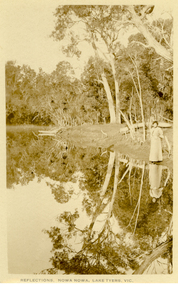
Postcard, Howard D. Bulmer, Reflections, Nowa Nowa, Lake Tyers, Victoria
Nowa Nowa is located in Victoria on the Princes Highway between Lakes Entrance & Orbost. Tall eucalypts stand guard as you drive into this small village.The fresh waters of Boggy Creek and the tidal waters of Lake Tyers meet here. In the past its history was of logging. Black and white post card showing a lady in long skirt standing on the banks of a river with Australian eucalypts (gum tress) in the background and reflected in the water. nowa nowa, lake tyers, trees, river -
 Federation University Historical Collection
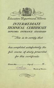
Certificate, Education Department, Victoria - Intermediate Technical Certificate, Diploma Entrance Standard, c1960s
Alexander McDonell was the Director of Education from 1960-1965Certificate printed on beige card. Signature of Director added Signature of Director of Education: A McDonell This is a blank certificate -
 Marysville & District Historical Society
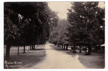
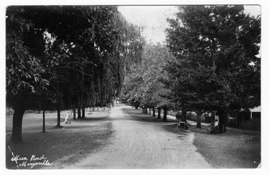
Postcard (item) - Black and white postcard, Main Road Marysville, Unknown
Postcard of early black and white photograph of the main street of Marysville in Victoria. This street is now known as Murchison Street.Postcard of early black and white photograph of the main street of Marysville in Victoria. This street is now known as Murchison Street.POST CARD PLACE/ POSTAGE/ STAMP/ HEREmarysville, victoria, murchison street, postcard, souvenir -
 Marysville & District Historical Society
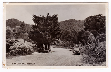
Postcard (item) - Black and white postcard, Valentine Publishing Co. Pty. Ltd, Entrance to Marysville V.11, 1923-1963
An early black and white photograph of the Marysville-Wood's Point Road at the corner with Murchison Street in Marysville in Victoria.An early black and white photograph of the Marysville-Wood's Point Road at the corner with Murchison Street in Marysville in Victoria. This postcard was published by the Valentine Publishing Co. Pty. Ltd. as a souvenir of Marysville.VALENTINE'S/ POST CARD/ A GENUINE PHOTOGRAPHmarysville, victoria, postcard, valentine publishing co, souvenir, murchison street, marysville-wood's point road -
 Marysville & District Historical Society
Postcard (Item) - Black and white postcard, Main Road Marysville, Unknown
Postcard of early black and white photograph of the main street of Marysville in Victoria.Postcard of early black and white photograph of the main street of Marysville in Victoria. This street is now known as Murchison Street.POST CARD PLACE/ POSTAGE/ STAMP/ HEREmarysville, victoria, murchison street, postcard, souvenir -
4th/19th Prince of Wales's Light Horse Regiment Unit History Room
Post cards, J Williams, c. 1918
Five black & white post card pictures showing parts of the Western Front. They are: 1. Peronne - Aspects of the town entirely destroyed by the retreating Germans, 2. The village of Feuilleres (Somme) (destroyed) , 3. Estrees (Somme) - Entrance of the village, 4. Neuve Eglise (destroyed) and, 5. La Buissiere, La Gare1,2,&3 Vise Paris No 853, 867 & 863 and description of location. 4 & 5 - location onlyphotos, western front -
 Ringwood and District Historical Society
Photograph, Hussey's Warrandyte passenger service cars at Ringwood Railway Station entrance circa 1930
... Catalogue card reads, "Entrance railway station. See Bruce... 1930. Catalogue card reads, "Entrance railway station. See ...Catalogue card reads, "Entrance railway station. See Bruce Bence's book of Hussey who ran the big black car to Warrandyte". -
 Ringwood and District Historical Society
Photograph, Main Street Ringwood, looking east late 1940's
Black and white photograph of Main Street, Ringwood. Clock tower in background in original position. (2 copies) Catalogue card reads, "Whitehorse Rd. looking east - south side 1935. Station entrance just past Carter's on right". Looking East from Whitehorse Rd, not 1935, late 1940s?, 2 copiesTyped below photograph, "Main St. Looking East. Railway Station entrance on right past Carter's - 1935". Small, original print has Main St c1949" written on back. -
 The Beechworth Burke Museum
Photograph, 1910
This photograph dating to 1910 depicts an open cut sluicing site located in El Dorado captured looking east up the open cut from the number 3 Barge site. Sluicing was undertaken in the area from 1900 to 1942 with some short breaks between these periods. The image depicts a location mined by Cocks Pioneer Gold and Tin Sluicing Company (as recorded on the annotation on the card mount). It portrays open cut rocks with a crevice in the center of the image where the sluicing was being undertaken. There is a small timber structure on the right of the image which could be an entrance to a mine or supports made of wood to prevent a cave in at the open cut site and above the cut rock there is bush. The timber structure has rail tracks on top of the bridge which could suggest the identification of this structure as a mine entrance. The rail tracks were used for little carts which hauled soil from the mine. The Cocks Pioneer Gold and Tin Mines N.L was one of El Dorado's two largest open cut sluicing mines of the 20th Century. The other was named the Cocks El Dorado Gold Dredging Company. The Cocks Pioneer Mines operated from 1901 until 1941 and found a total of 117,378 ounces of Gold and 1,673 tones of tin concentrates over these years. The Cocks company was formed in 1898 and operated until 1941. Open cut sluicing involved the use of high-powered hoses which used the centrifugal sand pump system (known as hydraulic sluicing) which broke down the soil which was then processed for gold and other precious metals. From 1914 , four years after this image was captured, the company reformed to Cocks Pioneer Gold and Tin Mines NL (previously it was known as Cocks Pioneer Sluicing Co) and undertook large scale sluicing operations until 1929 and then 1934-1941. El Dorado is located on Reedy Creek and is surrounded by forested country to the north and east. It is 20 km east of Wangaratta in Victoria's regional north-east. John Cock was the son of a Cornish minor who arrived in El Dorado in 1858. Cock founded his gold and tin mining company which ran successfully for many years in the El Dorado region. It was an open cut sluicing company because of the abandonment of underground mining after this was deemed too dangerous. In 1935 Cock's El Dorado Company commissioned the floating dredge which is still visible in El Dorado today. The dredge was built by the Thompson engineering works, Castlemaine, and weighed over 2,000 tones and today has a place on the Victorian Registers of historic buildings. Interestingly, the name El Dorado does not derive from the gold in the region, but from the Barambogie pastoral run completed by William Baker in 1840-1841. Gold was discovered in El Dorado 1854 but the gold was too deep for individual prospectors to find, it required the use of heavy machinery.The search for gold is ingrained into the history of Victoria and therefore, images like this one which portray an open cut sluicing site can reveal important information for society and technology for the date when the photograph was taken. This image is of important historical significance for its ability to convey information about sluicing and the methods used to find gold in 1910. It also shows a location where sluicing was undertook which provides insight into the impact of sluicing on the environment at a time when it was done. This image is important for current research into the history of El Dorado, a small regional location near Wangaratta in Victoria's North East. Therefore, this image has the capacity to be beneficial for research into society and the motivations of those living and working in this region during this period and therefore, has social significance. The Beechworth Burke Museum has additional images relating to gold sluicing and El Dorado which can be analysed and studied alongside images like this one.Sepia coloured rectangular photograph printed on gloss photographic paper mounted on board.Obverse: COCKS PIONEER Q + T SL CO, N.L. / 1910 / LOOKING EAST UP OPEN CUT / FROM NO3 BARGE SITE / Reverse: 1997 . 2611 / A02611el dorado, north east gold, sluicing, gold sluicing, hydraulic sluicing, 1910, gold and tin mine, open cut mining, mining, gold mining, north-east victoria, beechworth, burke museum -
 The Beechworth Burke Museum
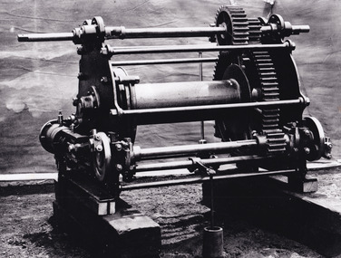
Photograph - Photograph - Reproduction, c.1870s
This photograph shows a piece of gold mining equipment identified as a mine winch, possibly an air winch cylinder of 1870s RG Ford's Patent design. Throughout the history of mining for gold and other precious materials, the windlass or winch (pictured) was used to bring up buckets full of soil from the bottom of a mine. This soil was then searched for gold/metals before being relocated to a different area. Due to the size and complexity of this particular piece of equipment, this winch may have been used to raise and lower mine carts to the entrance of the mine (often used in coal mining) and could have been used in raising cages up and down (acting as elevators) containing miners if the mine was particularly deep. The actual use of this particular item in the Beechworth locality is undocumented but these are some possibilities based on the use of these pieces of equipment in other mining locations. Mining can have a largely detrimental impact to the environment and therefore, the study of machinery like the one depicted in this photograph can help researches to reconstruct the methods and technologies used in the late 1800s and early 1900s. This particular item appears to have been removed from it's original site where it would have been used to assist with mining. It is possible that this photograph has been taken for recording purposes or as part of a machinery exhibition. Prior documentation records that this piece of equipment had connections to the Rocky Mountains Mining Company. Today, the Rocky Mountains Gold Mining company is famous in Beechworth for having been instrumental in the creation of the Rocky Mountain tunnel. Construction for this tunnel began in 1859 when a group of 12 men blasted a 400ft long tailrace though the rock beneath the town of Beechworth. Today, the 800ft tunnel, completed in 1871, is a popular tourist attraction but during the decades of gold mining, the purpose of this tunnel was to divert water away from the main sluicing operations so miners could better access gold and precious materials. The tunnel was used for this purpose for many years, later becoming useful for the Zwar Brother's tannery and currently as an outfall drain for Lake Sambell. This area continued to be mined until the early 1900s. The period when this item was in use is unclear but it is estimated to have been in the 1870s based on the design and appearance of the image. The gold works at the Rocky Mountain Tunnel closed in the early 1920s but the impact of mining remains in Beechworth today and therefore the study of photographs like this one which contain mining equipment can further understanding of mining in this region.This photograph has historic and research potential for study on the gold mining of the Beechworth region and types of equipment used to locate gold after the initial gold rush of 1853-1854 which resulted in the discovery of the surface gold and required miners to dig deeper to access precious metals. The clarity of the photo, and its good preserved condition, means it can continue to be used for research. This photo is part of a collection of six photos all within the Burke Museum Collection which depict mining equipment.Square black and white photograph on card.7793.1beechworth, mining, goldmining, goldmining equipment, beechworth burke museum -
 Port of Echuca
Colour photograph, Approx. 1979
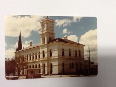
The old Echuca Post Office was built circa 1877, a two-storey stucco building with a clock tower over the entrance, on the north east corner of Hare and Anstruther streets. In the front of the building is a small cream brick kiosk used as a bus stop and as a stall for charity group's to sell produce. On the far northern corner the spire of St.Mary's church can be seen above the roof of the Post Office.The old Echuca Post office is at the northern end of the shopping precinct in Hare street Echuca. The building is a beautiful grand building of the late 1870's which was built as a post office on the ground floor and a residence above. The small kiosk building in front of the post office was used by volunteer organisations to raise money selling cakes etc. at various times of the year.Colour photograph (post card size) of Echuca Post Office looking north. The post office was built circa 1877, a two storey building with a clock tower over the entrance door. In front of the building is a small cream brick kiosk and bus shelter.Printed on the reverse "this paper manufactured by Kodak"echuca post office, echuca-historical buildings -
 Port of Echuca
Colour Photograph, Approx.1979
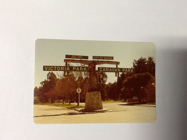
In 1869 the Council moved to name this park "Victoria Park. The cricket pitch construction began in 1873 and major improvements to the ground were undertaken in 1881. It is still the primary sporting ground in Echuca, offering AFL football oval, cricket pitch and nets, athletics and entry to the Echuca boat ramp and the natural bush land of the scenic drive. It also houses Echuca Council caravan park. The signage in this photograph is no longer there and the enterance to the caravan park has moved.This area of Echuca has historically been a major recreational area for the town. Being the primary sporting ground since its establishment in 1869., the area has a number of sporting and recreational facilities for the people of Campaspe Shire, from natural bush walks in and along the Murray river to more formal facilities such as AFL football ground, firefighting training area, netball courts, cricket pitch and nets, and grass tennis courts. Colour photograph (post-card size) of directory signs to entrance of Victoria Park, Echuca taken facing north. Two driveways are shown, to the east "Caravan Park" and to the west , "Victoria Park", "Boat ramp", " Scenic drive"Printed in black on the reverse:"this paper manufactured by Kodak"echuca, port of, echuca council caravan park, victoria park, echuca, echuca-tourist attraction -
 Port of Echuca
Colour Photograph, Approx. 1979
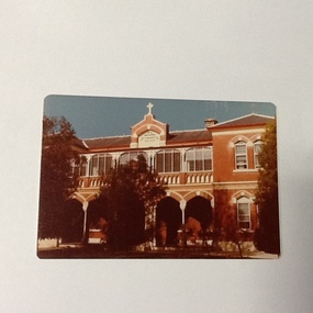
Formerly the home of Henry Hopwood. Apsley House, No. 1 Echuca. This was purchased for the Bridgine nuns to establish a catholic co-education school in Echuca. Extensions were made to the original structure (to the south of this building) with outbuildings and brick stables converted to school rooms during the late 1886 and opened as St Joseph's in 1887. The front section of the school was built in 1888. At the time of this photograph the upper floor of the building was the boarding house. The school building holds historical, social and spiritual significance to Echuca being the former home of Echuca's founder, Henry Hopwood. The diocese purchased the original building for 1,000 pounds. The school opened as a co-educational school on 22/3/1886 with 16 boys and 7 girls. It's first enrolment was a non-Catholic boy. By the end of 1886 there were 30 pupils. The boarding school opened on 4/5/1886 with 6 students. The chapel (to the north of this building) was built in 1889. For 60 years the school provided both primary and secondary schooling but in 1960's it changed to secondary schooling. The boarding house closed around 1986 and the school continued as a co-educational catholic college.Colour photograph (post-card size) of Bridgine Convent, Echuca (St.Joseph's College), showing arched facade over the verandah and the upper louvred windows of the boarding house.On front above the entrance "Brigidine Convent A.D. 1886.. Printed on the reverse:" this paper manufactured by Kodak"echuca- secondary schools, st joseph's college, echuca, brigidine convent, echuca -
 Williamstown Botanic Gardens- Hobsons Bay City Council
Postcard - Williamstown Botanic Gardens, c1900-1910
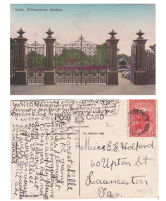
The original postcards in this series (2013.002 to 2013.018) were generously loaned to Williamstown Botanic Gardens by a private collector for copying. The cast iron gates (manufactured in Glasgow) introduced at the North West entrance in 1907. The gates were purchased from ‘Fairlie” corner of Acland and Anderson Streets, South Yarra at the cost of 72 pounds and cost 60 pounds to install. They had originally cost the owners of ‘Fairlie’ 1200 pounds. The postcards are evidence of the interest the gardens held as a subject for postcard publishers. The text and images provide a snapshot into fashions, social interests and concerns of the time. The professionally produced images provide a pictorial history of Gardens including changing planting styles, various structures and features of the Gardens eg the aviary, cannons, the fountain, the second Curator’s Lodge and gates. The images offer an opportunity to compare garden vistas with the present day. The image in this postcard shows the gates intact and as installed in 1907. The current layout of this area still reflects the change of design, which followed the 1907 removal of the first gardener's residence and the subsequent re-organisation of this quarter of the gardens. This postcard is evidence of the placement of one of the cannons relocated from Fort Gellibrand in 1906. They were removed from the Gardens in the 1960s. These same cannons remain a feature on the Williamstown waterfront in 2013. Postcard in colour of main entrance gates, one of the cannons can be seen through the pedestrian gate on the right. The gates are cast iron, double carriage gates with single pedestrian gates on either side and supported by four cast iron posts with ornamental finials. Front: ‘Gates, Williamstown Gardens’. Reverse: Vertical on left side of card ‘O Rippon Se..es’ [name of the publisher is unclear]. Top centre of card: ‘POST [logo of card publisher] CARD’. Left side of card: ‘This space may be used for communication.’ Right side of card: ‘for Address only.’ Left bottom corner: ‘Printed in ……..’ [name unclear]. Top right hand corner: a red one penny Tasmanian stamp with a depiction of Mount Wellington. Bottom right corner in pencil ‘1908’ believed to be inserted by the vendor. The card is dated 15.5.10 by the sender. It is addressed to Miss E G Holford of Launceston, Tasmania and sent by Addie.postcard, gardens, post-card, williamstown-botanic-gardens, hobsons-bay-city-council, entrance gates, entrance-gates, cast iron, finials, cannon, 1910, 1908, tasmania, tasmanian-stamp -
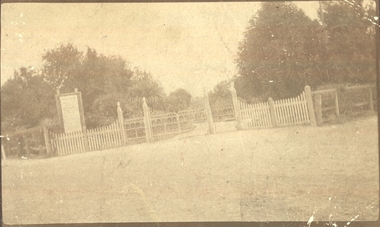 Port Fairy Historical Society Museum and Archives
Photograph
... ) Post card - correspondence-Address Entrance to Port Fairy ...Entrance to Port Fairy Botanical Gardens. The Port Fairy Botanical Gardens were formed in 1856 making it one of the earliest gardens in Victoria. The first curator was James Prior, he was paid fifty-two pounds per annum. He was an outstanding curator having been apprenticed to the trade in England at the age of 12, his brother Edward in later years was the Curator of the Koroit Gardens. Prior retired in 1903. During the years of his curatorship Port Fairy was said to have the best gardens outside the city of Melbourne, he was constantly in touch with Baron Von Mueller and later Guilfoyle of the Royal Botanical Gardens of Melbourne. In the early years plants from all over the world were planted here with varying rates of success many of them sent by Baron Von Mueller. In the 1930’ and 40’s the gardens were still very beautiful, and the curator was Roy Manuell. The beautiful iron gates at the entrance were destroyed in the 1946 floods and were replaced in 1989 using some of the material from the original gates. From the 1950’s on the gardens went into a state of decline, much being taken up by the caravan park until in 1986, after a public meeting ‘Friends of the Gardens’ was founded when the entrance section was restored. Sepia landscape of the gates to the Botanical Gardens (taken on a slant)Post card - correspondence-Addressbotanical, garden, park, griffith street, gates -
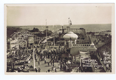 St Kilda Historical Society
Photograph, Whitney Bros Electric Post Card Studio, Luna Park, c. 1900s
Luna Park with crowd milling, aerial view from the entrance towers, St Kilda bay behind.black and white image on front of postcard, unmounted, good conditionFront: Luna Park From The Entrance Towers; Whitney Bros. Photo 18; Back: Whitney Bros, Electric Post Card Studio, Luna Park, St kilda. Melbourne, Australia. -
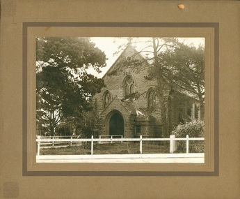 Uniting Church Archives - Synod of Victoria
Photograph, undated
St John's Presbyterian was built in 1853. It was used for worship services 1853 - 1927. It was subsequently used by church organisations for a further 25 years. Demolished in 1953. The front doors and stone entrance archway were reused by St. Thomas' Church of England Moonee Ponds.B & W exterior view of St. John's Presbyterian Church Essendon. Mounted on brown card.st. john's presbyterian essendon, bluestone, st. thomas moonee ponds -
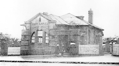 Surrey Hills Historical Society Collection
Photograph, Surrey Hills Post Office
The post office opened at this location in 1912. It was demolished in 2000. Post office history in the area: Until 1883 when the railway came through to Surrey Hills, this was essentially a rural community of scattered farms. Land subdivisions soon occurred along the railway line and limited postal services followed soon after, although a ‘permanent’ home for the post office was two decades away. George Sim Junior is acknowledged as our first postmaster; he opened a post office on 1 October 1884 in his father’s general store at 619-621 Canterbury Road, a few doors down from the Surrey Hills Hotel on the corner of Union Road. Over the next 20 years, the Surrey Hills Post Office moved several times into temporary, shared accommodation – in 1889 into Woodhead’s Corner Store at 364 Canterbury Road; then in 1895 to No 376, Hansen’s Exchange Building, part of Hansen’s Terrace (demolished) and in 1901 to 109 Union Road, on the corner of Windsor Crescent. Following Federation in 1901, the new Commonwealth Government established the Postmaster-General's Department to provide postal services to the nation. Many of the post offices constructed in the following years reflected a growing sense of Australian pride and nationalism. It was 1914 when building commenced on the ‘purpose-built’ post office at 609 Canterbury Road, Surrey Hills. Described as “a polychromatic Federation Freestyle building”, it served as the local post office for nearly 85 years until sold by the Commonwealth Government in c1999, after which the post office moved to the current, less prominent site at 100 Union Road. For nearly 10 years under private ownership, the building was successfully adapted for use as the base for two businesses, Gargoyles and Dragons and later the Surrey Sculpture Studio, and fortuitously the historic integrity of the building was maintained. However although renovated in the 1990's, structurally sound and of historic significance, it was not protected under local or commonwealth heritage legislation and was demolished soon after sale. This is an early image of a demolished building which should have been protected. In 1991, when the City of Camberwell conducted a heritage study, (which still informs the basis of the City of Boroondara’s heritage guidelines for this part of the municipality,) the post office was owned by the Commonwealth Government. As such, it could not be considered for heritage listing by the local authorities. Some years later, the Commonwealth and Australia Post rather belatedly recognized not only that post offices have heritage and social value, but also that the architecture of post offices as community buildings is important. A heritage management scheme was developed for the buildings they own or control under the Environment Protection and Biodiversity Act 1999. Unfortunately, the Surrey Hills Post Office had been sold and demolished before this was finally enacted in 2004. Black and white image, perhaps from a post card, of Surrey Hills post office at 609 Canterbury Road. The building is flanked by a picket fence. There is a woman, a dog and a man in front of the entrance. The man is in uniform - possibly a postal employee.post offices, canterbury road, businesses, surrey hills post office, surrey sculture studio, gargoyles and dragons -
 Kew Historical Society Inc
Photograph - 8 roomed DF Brick Villa, Kew, J E Barnes, c.1920
Subdivision plans are historically important documents used as evidence of the growth of suburbs in Australia. They frequently provide information about when the land was sold on which a built structure was subsequently constructed as well as evidence relating to surveyors and real estate and financial agents. The numerous subdivision plans in the Kew Historical Society's collection represent working documents, ranging from the initial sketches made in planning a subdivision to printed plans on which auctioneers or agents listed the prices for which individual lots were sold. In a number of cases, the reverse of a subdivision plan in the collection includes a photograph of a house that was also for sale by the agent. These photographs provide significant heritage information relating house design and decoration, fencing and household gardens. The photograph is of additional aesthetic significance as it was photographed by J. E. Barnes. Josiah Earl Barnes is a nationally significant photographer. He was also the most important photographer to have worked in Kew. He was active as a photographer in the district from c.1906 until his death in 1921. Best known as 'the Embarkation Photographer' (see the Australian War Memorial collection), J. Earl Barnes was also the official photographer employed by the Borough (and later Town, then City) of Kew. He clearly also completed commercial jobs for local businesses, as is the case in this photograph of a house for a local real estate and financial agent.A photograph, mounted on board of a double fronted Federation-era brick villa in Kew, photographed for a local real estate agent and financier by J. E. Barnes of Kew. On the reverse of the photograph is a subdivision plan for the Normanby Estate, East Kew - 2016.0039.1. As can be seen from the image, there is a large tear on the surface of the photograph.The brown card on which the photograph is mounted includes the following handwritten description, which may aid the identification of the house: "Kew, 3 minutes from tram, 8 roomed DF Brick Villa, tile roof including two attics, sleepout, bathroom, heater, E Light, Entrance Hall, double doors, leadlights, laundry, garden, lawns, land 75 x 170, 1975 pounds". Also photographers inscription on mount, lower left: J. E. Barnes / Photo / Phone 1966 Haw. KEW.j. e. barnes, josiah earl barnes, j. earl banes - photographer, architecture - federation style, houses - kew, real estate photographs -
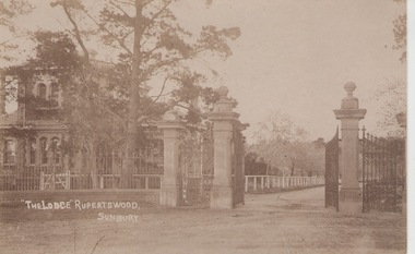 Sunbury & District Heritage Association Inc
Photograph, c1920s
The post card is of 'The Lodge' and the gateway to the Rupertswood Estate, which was owned by the Clarke family. 'The Lodge' was the former gatekeeper's cottage. A sepia photograph in postcard format of a two storey bluestone building partially hissed behind trees and an entrance with imposing gateposts and iron fence. rupertswood mansion -
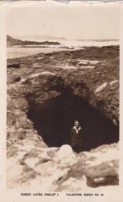 Phillip Island and District Historical Society Inc.
Postcard - Post Card, black & white, Forrest Caves, Phillip Island
One of a collection of Photographs/Postcards in a album donated by Bernard Grayden.Small black + white postcard. Image includes man in shirt and jacket standing at cave entrance, with ocean front in background."Forest Caves, Phillip I." Valentine Series No. 36forrest caves phillip island, bernard grayden, early postcards -
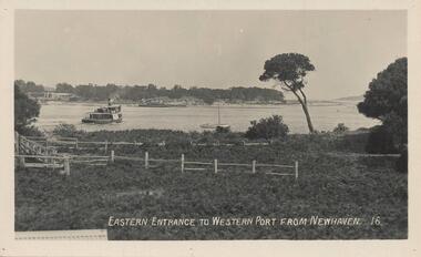 Phillip Island and District Historical Society Inc.
Photograph - Post Card, Early 20th Century
One of a group of photographs from the Bryant West Collection donated by Mary Karney.Black & White postcard of the Eastern Entrance to Westernport showing a Ferry and other vessels with San Remo on the other side of the bay.Eastern Entrance to Western Port from Newhaven. 16.western port phillip island, ferries, san remo, bryant west collection, mary karney -
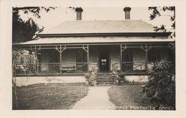 Phillip Island and District Historical Society Inc.
Photograph - Post Card, Early 20th Century
One of a collection of 8 photographs donated by Bob Notley, San RemoBlack & White Postcard of Broadwater Guest House front entrance, Cowes, Phillip IslandNo. 150 Front entrance "Broadwater" Cowesguesthouses cowes phillip island, broadwater guest house, broadwater guest house cowes, bob notley -
 Phillip Island and District Historical Society Inc.
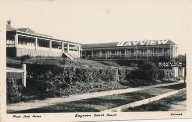
Photograph - Post Card, Unknown
Donated by Jean BainBlack & White Postcard of Bayview Guest House with "Bayview" written on roof and "Bayview Guest House" sign at front entrance. Hedged fence and street pathway in front.Photo Shop Series Bayview Guest House Cowes.bayview guest house, guesthouses cowes phillip island, phillip island, jean bain -
 Orbost & District Historical Society
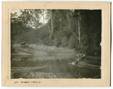
black and white photograph, late 19th - early 20th century?
Bunga Creek is approximately 5km east of Lakes Entrance.This is a pictorial record of horse-drawn transport of the late 19th century used in East Gippsland.A black / white photograph of a bush scene with a horse - drawn coach running along a track beside a creek.. It is on a cream coloured buff card.on back - "No. 5" on front - "At Bunga Creek"bunga-creek horse-drawn-coach -
 Eltham District Historical Society Inc
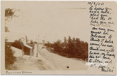
Postcard, Post Office, Eltham, 1906
Postcard sent to Mrs W. Heber Green (Adelaide May Green), 10 March 1906 From Millie. William Heber Green was a lecturer according to the 1909 Electoral Roll. Looking south along Maria Street (Main Road) from intersection with Bridge Street, Eltham, c.1906. Burgoyn'e Post Office on left. The footpath was about 2 feet above the road level. Horse and cart near the entrance to John Street. Webster's house was on the the northeast corner of Pitt and Maria (Main Road) and the verandah was over the footpath. Watson's Hotel on southeast corner, Fountain Hotel on southwest corner and Morrison's house on the northwest corner. (Doug Orford) Used post card with notePostage stamp and post marked Eltham Victoriaadelaide may green, bridge street, burgoyne, eltham, fountain hotel, main road, maria street, millie, morrison home, pitt street, post office, watsons hotel, webster home, william heber green -
 Eltham District Historical Society Inc
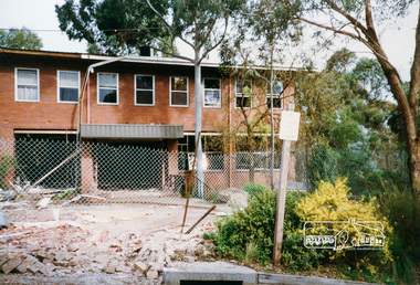
Photograph, Cr. Peter Graham, Looking at entrance to Shire Office building, Administration and CEO office, 12 Aug 1996, 12/08/1996
Demolition of the former Shire of Eltham Offices, 895 Main Road, Eltham, 12 August 1996. Originally mounted as a group of 9 photos on 42 x 55 cm display card.Colour photographeltham shire office, demolition -
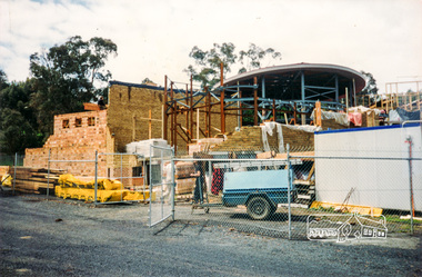 Eltham District Historical Society Inc
Photograph, Cr. Peter Graham, Steel posts in the library foyer entrance and display area, Eltham Library construction, Oct 1993, 1993
Construction of the new Eltham Library 1993-1994. Officially opened 22 May 1994. Formerly mounted on display card 40 x 50 cm (9 images)Colour photographconstruction, eltham library